Kipscombe Holidays - History of the area of Kipscombe
The History of Kipscombe
It can be found that the land around the farms has been farmed and lived on possibly since 1066AD
What we know about the Kipscombe area.
The main Kipscombe farm house, now North Kipscombe was mentioned in the doomsday book. There are remains of a medieval village just across the valley (visible from the 3 acre exercise field of Apple Orchard barn), there is a visible burial mound in a field next to our secure dog exercise field and the stream/brook of Kipscombe leads to a medieval water meadow dating 1540 to 1901.
The farmhouse/cottage at Kipscombe (middle Kipscombe as then known) was built around early 1800, built from stone, mud and lime and tile hung with slate tiles. The timber would have been oak, and the ground floors had flag stones. Sadly the house was left derelict for a while in the 1980’s and then completely rebuilt to a much bigger property as you see now. The only original stone walls are part of the rear south wall and an internal stone wall, which was then the north wall, which has been reduced to a single-story internal wall. Only 1 flag stone remains, and all oak timbers have gone. There was once also a Lower Kipscombe property that was in the valley but this disappeared many decades ago.
The Annex at Kipscombe was originally a shippen on a 110 acre farm, cows would have come and gone throughout the day. Then in the 1980's the farm reduced in size and the shippon was converted into stables and a tack room. In 2009 it was then converted into an annex as extra living accommodation for the previous owners of Kipscombe. In November 2015 Darren and Sarah purchased Kipscombe and the annex and converted the annex into a holiday cottage providing self-catering holidays in the beautiful North Devon Countryside. In October 2023 Kipscombe and the holiday cottage was sold to Paul and Vanessa who are also offering dog friendly holidays and the chance to stay and train.
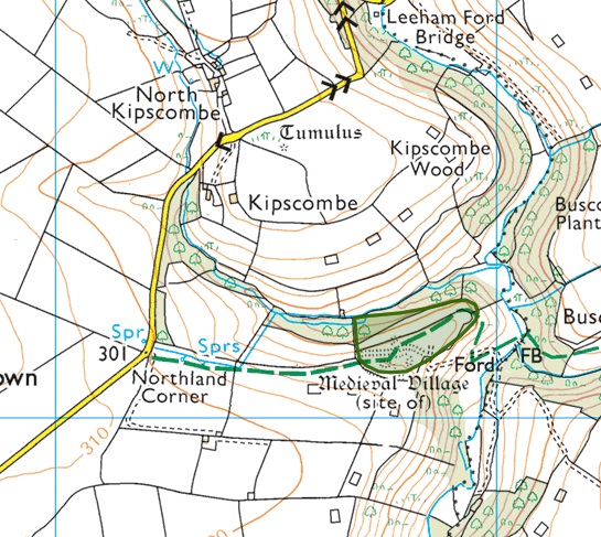
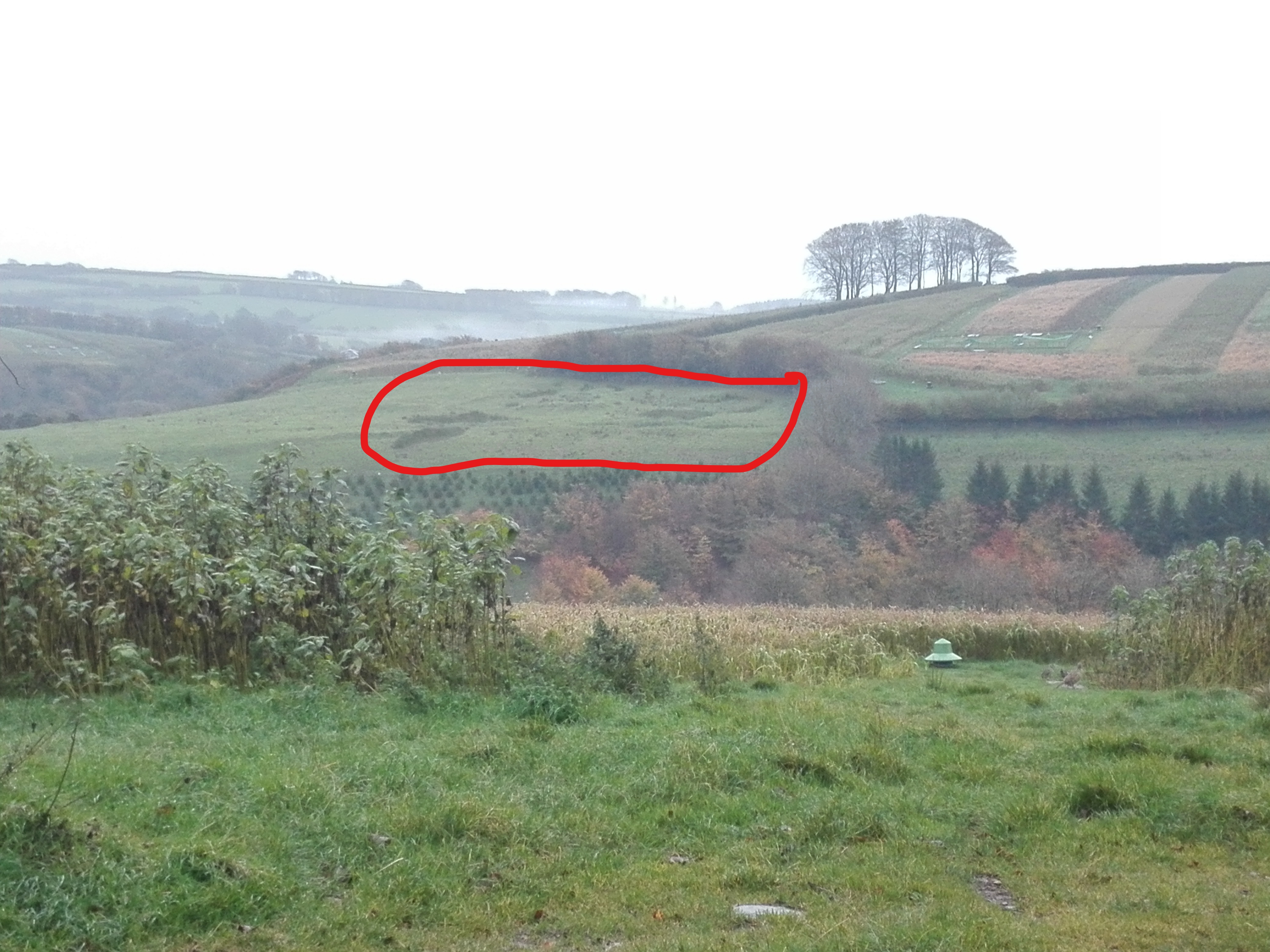
Kipscombe Deserted Medieval Settlement
The remains of Kipscombe deserted medieval village are visible on a promontory west of Wallover Wood, Bratton Fleming. They comprise a series of well preserved earthworks and banks including the remains of three long houses. Further down the slope to the north the remains of two lynchets are visible as earthworks on aerial photographs. The settlement is smaller than that at North Thorne in Bratton Fleming but the two are probably contemporary. (taken from the "Devon & Dartmoor Historic Environment Record”
Thought to date from 1066AD to 1539AD
The remains are visible from the field called “The Slom” at what was Kipscombe (now Apple Orchard Barn). Go to the south east corner and look south over the valley, you can just work out the village location.
Access: The remains of the medieval village can be easily accessed as a bridle way passes right by. When you arrive at the Kipscombe deserted medieval village you can see why that location was chosen. High up with access to fresh water via the spring fed stream at the base of the valley.
Parking: you can park in various places along the lane. Then follow the bridlepath from Northland Corner. You'll pass through a couple of wooden gates.
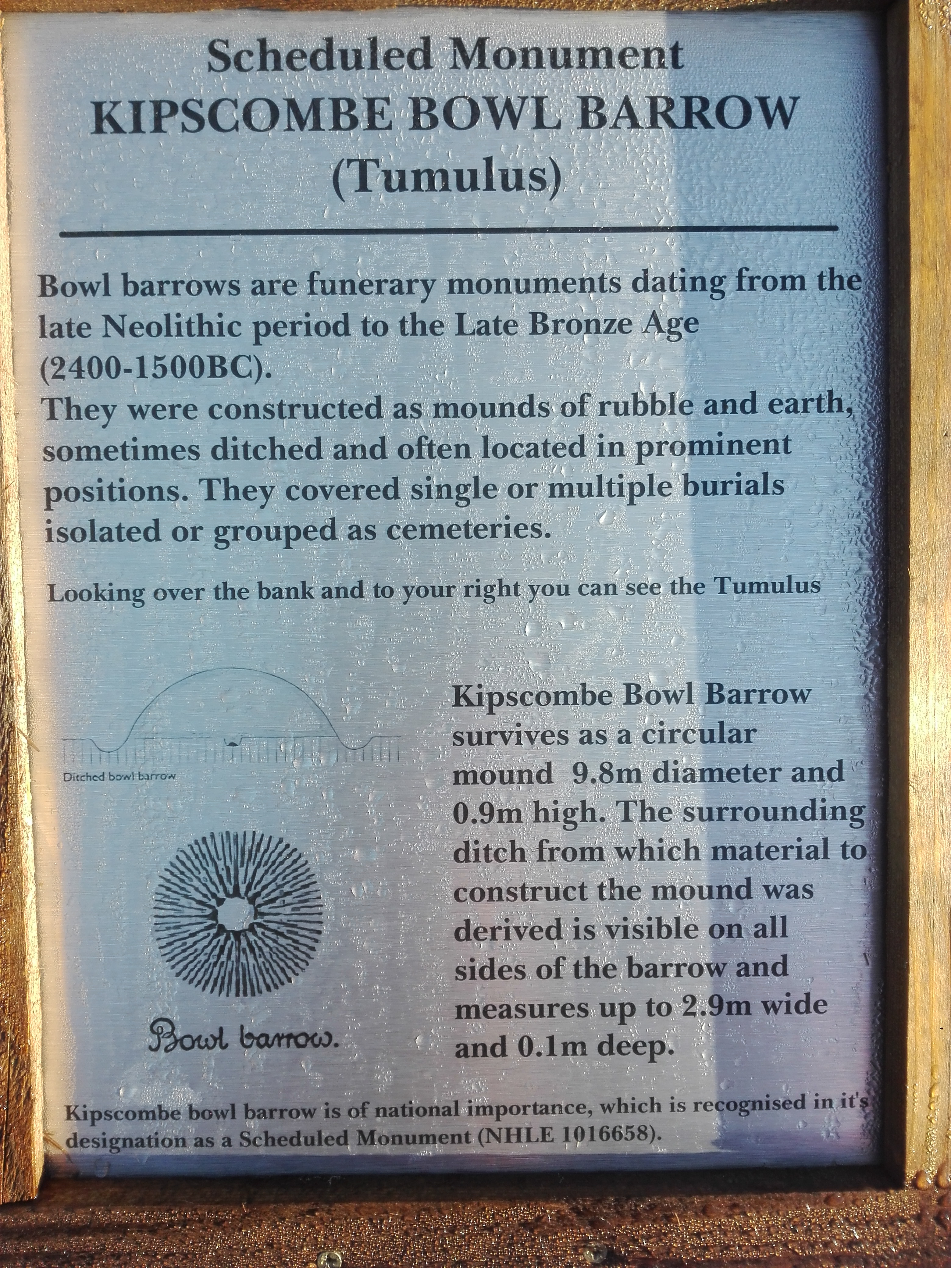
Kipscombe Tumulus Bowl Barrow
A Scheduled Monument in Bratton Fleming. Known as a Tumulus (bowl barrow, as shown on a map). It is visible from Kipscombe's field called the Slom. located to the north just over the Devon bank. It is easier to see in winter months when the hedging has shed their leaves.
Bowl barrows, the most numerous form of round barrow, are funerary monuments dating from the Late Neolithic period to the Late Bronze Age, with most examples belonging to the period 2400-1500 BC. They were constructed as earthen or rubble mounds, sometimes ditched, which covered single or multiple burials. They occur either in isolation or grouped as cemeteries and often acted as a focus for burials in later periods.
This monument includes a bowl barrow situated on a high upland ridge which marks the watershed of two tributaries to the River Bray. The monument survives as a circular mound which measures 9.8m in diameter and is 0.9m high. The surrounding ditch from which material to construct the mound was derived is visible on all sides of the barrow and measures up to 2.9m wide and 0.1m deep. An excavation trench measuring 2m wide and extending from the top of the mound towards the south west is just visible. As a result the mound generally slopes on the top in a south westerly direction.
Despite reduction of the Tumulus height through cultivation and disturbance through partial excavation, Kipscombe bowl barrow survives well and will contain archaeological and environmental information relating to the monument and its surrounding landscape. Information provided by a www.ancientmonuments.uk/114868-kipscombe-bowl-barrow-bratton-fleming#.W_6T2Yv7Tcd
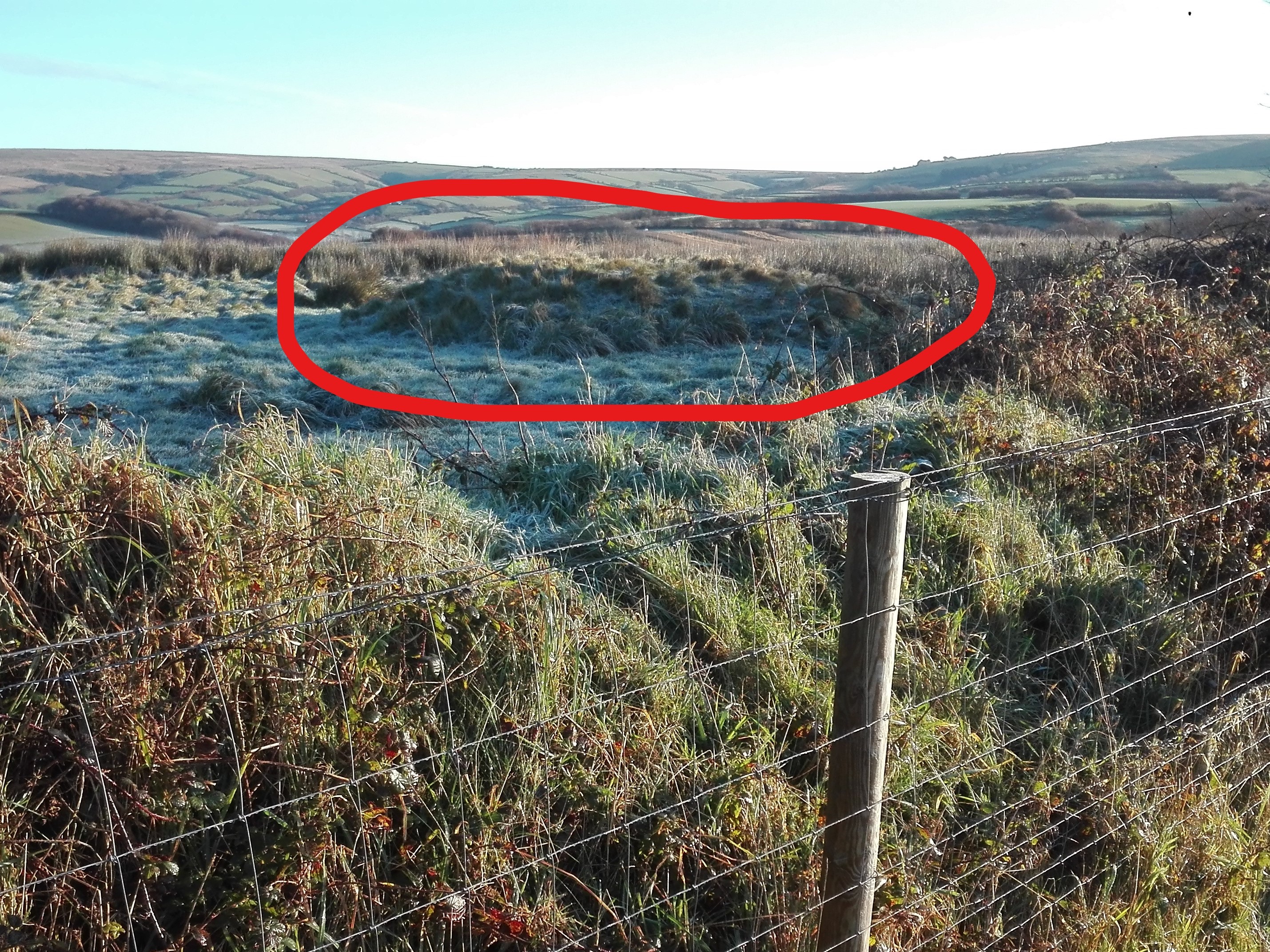
Access: There is no access for the public as it is on private land but is visible from the secure dog walking field at Devon Banks Holidays.
Kipscombe hamlet consists of just three residential properties and two 1 bedroom holiday lets allowing people with dogs. The holiday lets provide an ideal base to explore Devon, Somerset and Exmoor. They are truly dog friendly, walkers friendly and cyclists friendly as you'll find many attractions nearby. Enjoy a relaxing break in the North Devon countryside with great scenery to view.
Located just 1.2 miles from Exmoor National Park, a short walk or drive and your in the national park, you'll find an abundance of wildlife and occasionally may get to see local red deer, Barn owls, Tawny owls, birds of prey and if you're lucky, woody the woodpecker.
The hamlet of Kipscombe as it stands now consists of North Kipscombe a working 100 acre farm, Kipscombe a 3 acre non working farm with a 1 bedroom Holiday Cottage and Apple Orchard Barn, an 8 acre non working farm with a 1 bedroom holiday cottage also. The hamlet is located on a quiet country lane between the villages of Bratton Fleming and Challacombe in North Devon and is within walking distance of Exmoor where you can enjoy hours of cycling, walking or dog walking. After your long walk on the moors why not pop into the well known Black Venus pub in Challacombe which serves good beer and food or the Old Station House Inn at Blackmoor gate, also serving great food and ales.
Also found within the Kipscombe hamlet is The North Devon secure dog walking field and certified touring site with just a couple of pitches available.